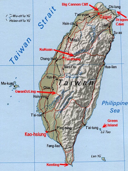
![]() Taiwan
climbing areas locator map
Taiwan
climbing areas locator map
Artificial Climbing Walls*
![]() Taipei
Walls & Gyms: Raymond's
Guide to Taipei Climbing
Taipei
Walls & Gyms: Raymond's
Guide to Taipei Climbing
![]() Kaohsiung
Gym: Kaohsiung
climbing gym information
Kaohsiung
Gym: Kaohsiung
climbing gym information
![]() Taichung
Walls & Gyms:
Taichung
Walls & Gyms:
Together: Giant Outdoor Spirit (04) 2475 8525
Taichung City, Wen Hsin Rd., Sec. 1, #17
台中市文心路一段17號 [pics]Sun & Tree Outfitters (04) 2471 4655
Taichung City, Wu Chuan West Rd., Sec. 2, #316
台中市南屯區五權西路二段316號 [pics]Outdoor Fun Taiwan (04) 2245 0678
Taichung City, Chung De Rd., Sec. 2, #330
台中市崇得路二段330號 [pic]
(*There are many other artificial walls around Taiwan. Many are
at colleges and universities. Just check with some of the local climbers
to find out where they are and if they can be climbed on by "outsiders".)
Real Rock Around Taiwan
This description assumes you will be driving your own car or riding with someone else. If you want to use public transportation, see below. (The guidebook has a more detailed description for using public transportation but it may be out of date.) Get on the #1 Freeway headed north toward Keelung. Soon after the #1 Freeway passes under the #3 Freeway (a.k.a. "the second northern freeway", "bei er gao") northeast of Taipei, there is a tollbooth. Travel 6 kilometers beyond this toll to an exit marked by a sign to the North East Coast. Stay on this road for 14 kilometers until it ends at the East Coast Highway #2. There will be a medium sized harbor immediately in front of you. Turn right onto Highway #2. Drive 12 kilometers on Highway #2. There will be a small harbor to your left with a small access road leading along its south side. Turn left off of Highway #2 onto this access road (there is a traffic light at this intersection, but it is not always working). Drive to the big parking area at the end of this little road and park. There is a small pavilion next to the elementary school. A number of people camp on the concrete slab beyond the pavilion. If the school is open, this is the place to use the toilet (actually this is only if you really need to; you'll understand if you ever have to). If not, you can try to beg at one of the little stores. You can rent a cold shower for 20 NT (about $0.70 US). There are numerous scuba divers in the warmer months who park here as well and use the showers. At the end of the parking lot is a little more road that ends at the tumbled rocks. Hike through these rocks and a narrow path through the saw plants (caution!) to the first band of cliffs. This first band is quite popular for it's easy location and some easy climbing. Much more climbing exists beyond these shorter cliffs. Just keep hiking. BTW, be sure to bring a swimsuit and towel for quick dips in the ocean. It just might make the heat of the summer months bearable. The cliffs go into the shade in the afternoon, so you may want to plan accordingly.Public transportation to Lung Tung:
First go to the main train station in Taipei, and then flash this around:1. 可以請你告訴我如何去台汽北站嗎?
Can you please tell me how to go to the Taipei bus terminal North Station?
2. 我想買到龍洞的 (單程 / 來回) 票
I would like to buy a (one-way / round-trip) ticket to Dragon Cave.
3. 我想在龍洞灣的第二站下車
I would like to get off at the second stop of Dragon Cave Harbor.
The "national" bus service has been privatized. You still go to the same north bus station, and the boarding gate is #4. The buses only run at 8:30am and 11:30 am; no more early morning runs.Northern Taiwan Area map showing proximity of Lung Tung and Big Cannon Cliff to Keelung, Taipei and CKS Airport. (158k)
![]() Big
Cannon Cliff - Taipei [online
climbing guide] [pics]
Big
Cannon Cliff - Taipei [online
climbing guide] [pics]
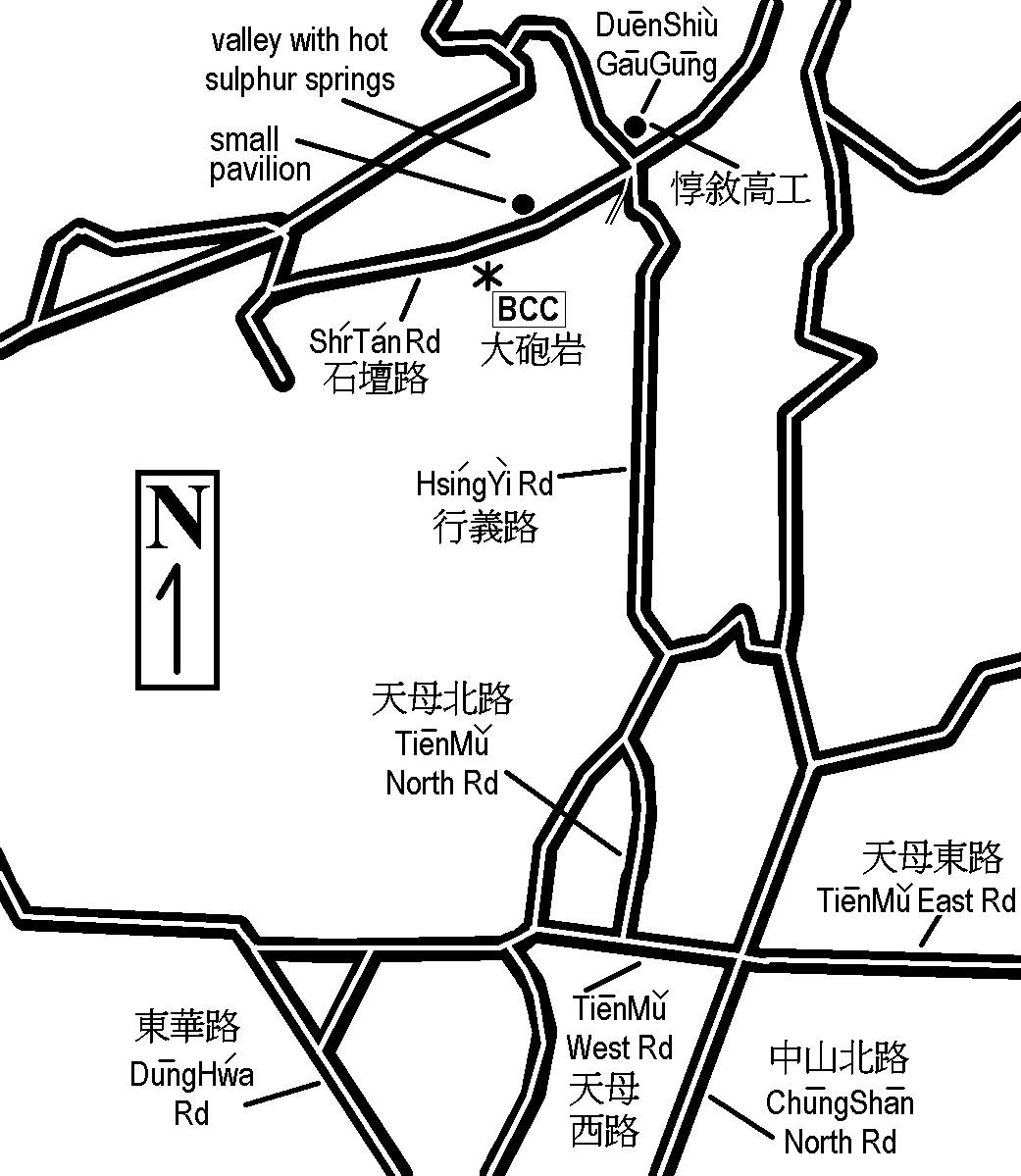
Directions to Big Cannon Cliff: From Taipei City, head north on ChungShan North Rd. toward TienMu. Turn left onto TienMu West Rd. Turn right onto TienMu North Rd. Merge into HsingYi Rd. heading north. You will eventually come up to the intersection at ShrTan Rd. The DuenShiu Vocational High School is on the northeast corner. Turn left onto ShrTan Rd. and head west, downhill. (Do not drive up the small road to your left which goes to the Tourist Information Center.) Shortly you will pass a small pavilion on your right (about 0.5 km. from the intersection). A little ways further you will be able to look up to your left and see the short cliffs on the hillside. There is a small retaining wall on the left hand side of the road and a large tree on the right. If the paint has held up, you will see the characters for "DaPauYan" (大砲岩) on the retaining wall. A short trail leads up to the east end of the cliff band.
A taxi from Taipei American School in TienMu will cost you about NT$120 (1998 rates).
Alternately, you can take bus numbers 508, 612 or 230 to the stop for DuenShiu Vocational High School (DuenShiu GauGung) and walk the rest of the way. It’s only a few minutes walk down to the cliff.
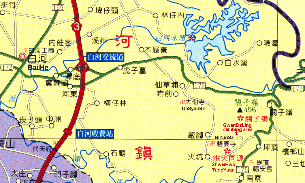
Ok, just so you don't get mad at me later, let me say now that GwanDzLing is not a great climbing area. The rock just isn't that good. But it does have one very important quality going for it; it is relatively near to Taichung. Those of us who live in the "Central City" don't have a lot of close by options, so climbing at GwanDzLing might interest you if you live anywhere between Taichung and Tainan. The drive from Taichung can take as little as 1.5 hours. If you live elsewhere, just take a look at a map and judge for yourself. The cliffs are less than 11 km. from Freeway #3 (the second central freeway), making access quite convenient. The directions below begin from the BaiHe (White River) exit of Freeway #3, heading east on highway #172.Check your odometer at the Freeway #3 exit ramp. Drive east on #172 toward the foothills. At approximately 4.2 km from the freeway you will see signs for highway #96 South. Just before the intersection there is also a sign in Chinese and English for directions to DaSyanSz and ShweiHwoTungYuan. There is a traffic light at this "T" intersection and you will turn right onto #96. After driving 0.9 km on #96 (5.1 km from the freeway) you will come to the DaSyan Temple complex. Drive right on through. You will begin to wind your way steeply uphill. At 8.7 km from the freeway you will come to a fork in the road. Take the left fork and drive through the BiYun Temple complex. The road again winds its way steeply uphill. You will come to another fork in the road at 9.4 km from the freeway. Again, take the left fork. At 9.7 km from the freeway you will pass through the ShweiHwoTungYuan complex. At 10.6 km. from the freeway you will see a red tile building on the left hand side of the road with a gate just beyond it (also on the left). If the gate isn't open, park here and slip past the side onto the asphalt road beyond. If the gate is open turn left through this gate and drive uphill for 500 meters to a sharp switchback with a vine-covered gate on the right side of the road. Park here and slip past the gate onto the concrete road on the other side. Walk 100 meters forward and slightly downhill to where you will see the "Extreme Rock" up the hill to your left. There is a double retaining wall to climb up and then a short climb up a steep embankment before reaching the base of the "Extreme Rock." Follow the trail to the right to find more cliffs. If you miss the vine-covered gate and come to the communications tower above, you have gone 200 meters too far.
![]() KuKuan(military
training area; possibly still closed) [pics]
KuKuan(military
training area; possibly still closed) [pics]
I haven't been to the climbing area at KuKuan in a while, so I haven't figured out the exact mileage. But it isn't too hard to find even without it.The first thing to do is to find KuKuan on a Taichung County map. It is east of Taichung city, part way up the central cross-island highway (Highway #8). The climbing area is shortly before the tourist town of KuKuan (I believe less than 5 km away, but don't count on that). Shortly before KuKuan there is a military base on the left side of the road. You will likely notice a guard standing duty at the gate. Wave as you drive on by (those guys have a boring job). A little farther up the road you will come to the back gate of the military base. Opposite the gate on the right side side of the road is a steel roofed, open sided building between the road and the river. This building is used by the military to practice rappelling. Park your car here. Follow the obvious footpath back downhill from the building, and you can wind your way down to the river.
![]() Kenting[pics]
Kenting[pics]
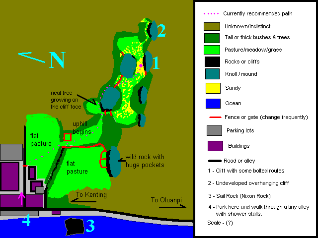
I am aware there are a few semi-developed cliffs in Kenting for rock climbing. However, except for Sail Rock and the small crag up in the hills to the east, I haven't been to any other "developed" areas. Sail Rock is obvious on every tourist map of the Kenting area, so I will use it as the reference point to the small cliffs to the east. Park in the lot on the west side of the highway just north of Sail Rock. From the south end of the lot, cross the road and walk a few meters north to the first small alley between the buildings. This alley is lined with shower stalls for people returning from snorkeling. Walk through this alley and up the lane to where there is a hotel parking lot on your left. Then head in a southeasterly direction toward a small opening on the far side of the pasture. This description ends here, so look at the map to find the rest of the directions. The map is not highly accurate, but if you tend in an easterly direction, you should be able to make your way to the cliffs. I'm guessing it's about a half-kilometer from sail rock as the crow flies. The bushes and saw plants grow rather quickly, so you may find the "path" a bit overgrown. Just push on through and you will probably get there. I usually carry some sort of machete. Note--there are snakes in Kenting National Park in abundance. I have seen them, especially in the thick brush, but they can be anywhere. Most of Taiwan's snake species are poisonous and some are quite deadly. Just don't do anything too stupid like try to pick one up. The large water buffalo in the pastures are not considered dangerous, but don't go out of your way to annoy them anyway. Also, if you damage a fence while climbing over or under it, please look around for something to repair the damage you have done. We want to keep the locals happy.As of July 2002 there are four routes at the first of the two cliffs shown on the map (cliff #1) and no routes at the second, more overhanging cliff (cliff #2). The first two routes (starting from the right) were bolted some time prior to the summer of 1998 (that's when I first climbed them). I think the second route is easier than the one on the far right. Those bolts were glued in according to a climber who witnessed the bolting, but, having pulled some, I don't think they are glue-ins. Unfortunately they weren't stainless steel either. I replaced the bolts on the second route in December 2000. I chopped or pulled the original bolts with the exception of the two top anchor bolts, which I left in place. I added a single anchor bolt with a quicklink and steel biner. I also placed one new bolt at the top anchor of the right route. Be forewarned; the rock at the top of the right route is very soft. Having seen the condition of the old bolts, I would not lead the right route until they are replaced. The third route (from the right) was bolted by me in April 1999 (named "Displaying Very Little Talent"). I used three-inch long stainless steel Fixe bolts with stainless steel hangers and drilled the holes the "old fashioned" way (no power drill). There are two bolts for the anchor, one should still have a permanent stainless steel carabiner attached. The route stops a bit short of the top with the "finishing jug" a bit up and right of the final bolts. Regarding my bolting job, no, it's not perfect, and yes, there are some "possible" nut placements on the route that could maybe eliminate one or more of the bolts. However, after blowing out a few hook placements while hanging to drill, I don't feel guilty about my choice. I think the route goes at about YDS 5.9 if you completely avoid the chimney crack to the left near the top of the route. Please let me know if you think differently. The fourth route (furthest left) has a single bolt anchor at the top of the cliff, but there are a number of options for backing it up (trees, nuts, etc.). This anchor can be accessed by climbing "Displaying Very Little Talent" and traversing over to it. Or, you can walk to the left side of the cliff and follow a trail up to the top of the crag. A little bush whacking should take you to the edge of the cliff where you can set up the anchor for a toprope. There are no lead bolts on this climb as of yet, and I probably won't bother since the top of this particular climb is accessible (at least until the saw plants grow back). Again, carrying some kind of machete might be a good idea.
![]() Green
Island [pics]
Green
Island [pics]
Ok, admittedly Green Island cannot be considered a true climbing "destination". There's just not enough there. But if you are a climber and you are planning a trip to Green Island for its other attractions (fantastic snorkeling), go ahead and take along a minimal amount of gear and either boulder or set up a toprope on some interesting basalt columns beside the sea. The cliffs are located about halfway around the island from the airport (you will definitely want to rent a scooter for your stay on Green Island). Unfortunately I didn't make exact measurements, so you will have to look for landmarks. At a particularly high point on the road (there really is only one road to speak of) you will notice a small sight-seeing pavilion about a hundred meters away out on top of the cliffs overlooking the ocean which is fairly far below. You can park your scooter and walk out to the pavilion on the narrow walkway. If you are facing the ocean you will see a "beach" below the cliffs to your right (the "beach" is not sand; we found only one sand beach on Green Island). Part of the way across this oceanfront you will see a very dark, almost black group of rocks sticking up out of the ground and out of the water. Those are the tilted basalt columns. After returning to your scooter, drive a very short distance in the direction of those rocks and you will see a sign on the ocean side of the road indicating a trail down to the oceanfront. Park here and hike down through the heavy growth which eventually deposits you at sea level. A short walk ahead will take you to the basalt rocks.I took a bunch of gear down since I didn't know what I would need. Since there are no bolts and no trees at the top of the rocks, you will need at least some trad gear to set up your toprope anchors. I used nuts and smaller SLCD's. I did not climb on the formation out in the water even though it looked cool. I didn't have a lot of time and I didn't want to get my gear wet, so I set up on the rocks sticking out of the ground instead. Although the basalt rock is hard, there is a substantial amount of loose rock and flakes on the surface, so be careful where the belayer and other people stand below. The routes I set up were quite easy on less than vertical rock, but still a bit of a challenge for the novice. Some harder routes could be found.
? More
questions? Click here to drop me a note at (taiwan_rock [at] yahoo.com)..
![]()